
Tropical cyclone not expected to hit SA
Idai is expected to make landfall too far north to affect South Africa
AS much of South Africa has experienced torrential rain and severe thunderstorms, all eyes are now on tropical cyclone Idai as the system gathers more speed off the coast of Mozambique.
Zululanders, particularly those in the region’s northern reaches, are tracking the system which is rapidly gaining speed.
Earlier this morning Storm Report SA reported that Idai was north-northeast of Europa Islands and moving at speeds of 11km/hr compared with yesterday’s 4km/hr.
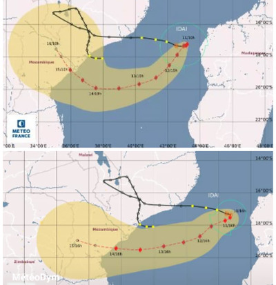
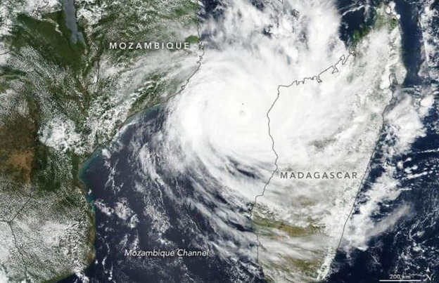
PHOTO: Storm Report SA/Facebook
Cooler waters and dry air on Monday night saw a slight eyewall collapse, but Idai is expected to regain intensity over the next 12 hours and make landfall in Mozambique on Thursday, slightly southwest of the initial trajectory.
According to Storm Report SA, Idai is an intense category four tropical cyclone.
Forecasters are monitoring Idai every hour but still do not expect the system to affect South Africa, but this can only be confirmed once landfall has been made.
The system is, however, expected to wreak havoc in central Mozambique, bringing with it torrential rain and high-speed, damaging winds, putting many impoverished lives at risk.
It may possibly also affect far eastern Zimbabwe, but would be too far north to affect South Africa.
What makes Idai a tropical cyclone is it’s Indian Ocean location, winds in excess of 119km/hr forming over ocean surfaces of at least 27 degrees Celcius, and the fact that the system is powered by latent heat from the condensation of water vapour in the atmosphere.
HAVE YOUR SAY
Like our Facebook page and follow us on Twitter.
For news straight to your phone invite us:
WhatsApp – 072 069 4169
Instagram – zululand_observer